With more than 100 tribes and a human history dating back thousands of years, California is filled with onetime Native American settlements and cultural sites. Many are located on tribal land with limited or no public use, but other culturally significant places are accessible at California’s state parks. In fact, the California State Park system preserves what its website describes as “an unparalleled collection of culturally and environmentally sensitive features and ancient habitats, including many significant California Indian villages.”
Visit the state parks and you can learn about local and regional Native American history in park museums, and also explore areas little changed since the time, before the arrival of Europeans, when anywhere from 300,000 to 1 million indigenous people lived in California.
Ranging from the redwood forests of the North Coast to the foothills of the Gold Country, the following destinations in the state’s northern half (roughly north of the San Francisco Bay Area) are among those identified by the state parks as offering the best opportunities to discover the world of California’s indigenous peoples.
The following state park destinations are listed from north to south.
Ahjumawi Lava Springs State Park
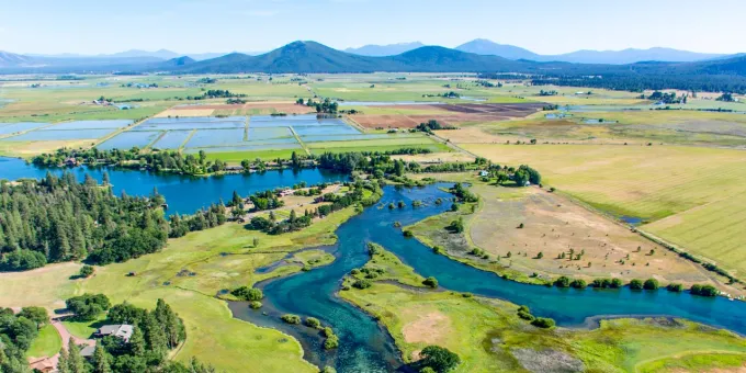
A unique destination accessible only by shallow-draft boat, Ahjumawi Lava Springs State Park in Shasta County’s Fall River Basin is named for the Ahjumawi, the people who have lived in this area of sparkling bays and tiny islands for thousands of years. The Ahjumawi are a band of the Pit River Tribe and the name, appropriately enough, translates as “river people” or “where the waters come together.” The park encompasses what is considered one of the largest freshwater spring systems in the country. And park areas not inundated by water, are largely covered by lava flows.
In pools along the shoreline, the Ahjumawi constructed fish traps with walls made of volcanic stone. They used these traps to capture a staple of their diet, the Sacramento sucker, and, to a lesser extent, rainbow trout. Not only did the traps make fishing easier, they also enhanced spawning conditions for the sucker, thus helping to perpetuate the Ahjumawi food supply. The traps are still used for traditional fishing. Eagle Eye’s Kayak Guide Service leads tours of the park’s waterways and you can rent kayaks and car racks from Headwaters Adventure Company in Redding.
McArthur-Burney Falls State Park
Home to today’s Pit River Tribe, the area around McArthur-Burney Falls Memorial State Park has a documented Native American presence that dates back an estimated 7,000 years. More than 20 sites within the park, which is located about 64 miles northeast of Redding, are listed on the National Register of Historical Places as part of the Lake Britton Archaeological District.
McArthur-Burney Falls, the 129-foot waterfall that plunges in multiple cascades down a moss-covered basalt cliff and into a cerulean pool, is sacred to the Pit River people, who still visit this spot for pilgrimages and coming-of-age ceremonies.
Sue-meg State Park
Thirty miles north of Eureka, coastal Sue-meg State Park is on the lands of the Ner’-er-nerh/Coastal Yurok people, whose descendants are now members of the Yurok Tribe, Resighini Rancheria, and Trinidad Rancheria. Formerly known as Patrick’s Point State Park, Sue-meg is the original Yurok name for this beautiful area of Sitka spruce forests and rich tidepools, and where gray whales are frequently spotted migrating offshore. The local indigenous community had continued to use the name Sue-meg, and the park became California’s first to be renamed under the Reexamining Our Past Initiative.
The initiative aims to change derogatory or inappropriate placenames and enhance interpretation to more fully tell and contextualize the state’s history. Yurok tribal chairman Joseph L. James called the name change a historic “turning point in the relationship between tribes and the state.”
At Sue-meg, you can visit a reconstructed Yurok village with several houses and a sweathouse made of redwood planks, and also see a traditional Yurok redwood canoe. The native garden is home to plants used for traditional medicines, basketmaking, and food. And during summer, the Yurok occasionally conduct ceremonies at the village that are open to the public.
Fort Humboldt State Historic Park
The 1849 discovery of gold on the Trinity River led to events that disrupted thousands of years of traditional hunting-and-gathering life for 14 North Coast tribes, among them the Yurok, Hupa, and Wiyot. When gold miners and settlers poured in, bloody conflicts ensued as indigenous peoples were forced from their lands, including vital hunting and fishing grounds. In 1853 Fort Humboldt was established on a rise overlooking Humboldt Bay near Eureka to restore peace and the site is now managed as Fort Humboldt State Historic Park.
Only the hospital remains of the original 14 buildings along the parade grounds at the fort where future United States President Ulysses S. Grant (then an Army infantry captain) served for a time. The old hospital now houses a museum that includes displays about the area’s Native American people.
Lake Oroville State Recreation Area
Busy with houseboats, water skiers, and anglers trying to hook rainbow trout and bigmouth bass, Lake Oroville State Recreation Area is a popular summer escape. Beyond its recreational appeal, this Butte County destination outside Oroville has a long history for the Maidu people, including the Oroville-based Estom Yumeka Maidu Indians of the Enterprise Rancheria and Konkow Valley Band of Maidu Indians.
Displays at the visitor center explore Maidu culture and include a video about Ishi, the Yahi man who emerged from the wilds outside Oroville in 1911 and was considered the last surviving member of his tribe. A self-guided nature trail describes how indigenous people used native plants, and the recreation area has hosted occasional Native Ways festivals that include dances and demonstrations of traditional crafts.
Clear Lake State Park
Along the southwest shore of Clear Lake and about four miles from Kelseyville in Lake County, Clear Lake State Park is best known for its outdoor recreation but also has a deep history as part of the Pomo world.
The Xabenapo Pomo harvested the lake’s reeds to craft tule boats for fishing and exquisite baskets both for ceremonial and daily use. For a good introduction to Pomo life, follow the self-guided half-mile Indian Nature Trail, an interpretive path that travels through a village site and offers information about how indigenous people lived off the bounty of the land.
Anderson Marsh State Historic Park
Along the southeast corner of Clear Lake, both the largest freshwater lake within California’s borders and the oldest in North America, Anderson Marsh State Historic Park is notable for its ancient sites. The oldest date back 14,000 years when the Koi people were among the first humans to settle in California. The park’s prehistoric sites are now included in the Anderson Marsh Archaeological District, which is enshrined on the National Register of Historic Places.
In a PBS documentary about Anderson Marsh, the Koi Nation of Northern California’s tribal chairman Darin Beltran said, “To reside in an area for 14,000 years is mind-boggling…This area had so much to offer that there are obvious reasons why they didn’t have to go far. They were spoiled, I believe they lived in paradise.”
The park is situated about 45 minutes north of Calistoga. In addition to a trail network that lets you explore the natural world that supported the Koi with acorns, building materials, and obsidian for tools, the Anderson Marsh Interpretive Association leads guided nature walks and exhibits artifacts in the park’s South Barn.
Salt Point State Park
An enormous, 6,000-acre park that stretches inland from the Sonoma County coast, Salt Point State Park, north of Jenner, was originally part of the Kashaya Pomo homeland. Their descendants now belong to the Kashia Band of Pomo Indians of Stewart’s Point Rancheria.
The Kashaya ranged through these lands on a seasonal basis, spending summers by the coast and winters in more established villages farther inland. Along the ocean, they gathered sea salt from crevices in the coastal rocks, both for their own use and to trade. Abalone, mussels, and an assortment of fish, including lingcod and rockfish, provided a plentiful food source.
Interpretation is minimal but 20 miles of trails lead through the park, and Gerstle Cove State Marine Reserve protects a stretch of coast with tide pools filled with the kinds of intertidal creatures the Kashaya depended on for food. No marine life can be taken at the preserve, but many other park areas are open for fishing and abalone diving.
State Indian Museum State Historic Park
Established in 1940, State Indian Museum State Historic Park in downtown Sacramento takes a comprehensive look at California’s Native Americans, from prehistory and into modern times. Their documented presence dates back at least 14,000 years and the state’s indigenous population was so diverse that more than 300 dialects were spoken around California, making it the country’s most linguistically diverse region.
The museum displays a remarkable range of artifacts, including a huge collection of baskets, hunting and fishing tools, and a Yurok redwood canoe, as well as contemporary works by California Native American artists. The museum hosts an assortment of events throughout the year, such as June’s Honored Elders Day, crafts demonstrations, and November’s Native Arts & Crafts Market.
Indian Grinding Rock State Historic Park
Indian Grinding Rock State Historic Park certainly lives up to its name. That’s because this park outside Jackson in Amador County is where you’ll find 1,185 mortar holes used by Native Americans to grind acorns and seeds, which were staples of their diet. No site in North America has more bedrock mortars, and their existence is testament to the area’s abundance.
In addition to the mortars and petroglyphs visible within the limestone rock, the park also has a reconstructed Miwok village with one of California’s largest roundhouses and a field for a soccer-like game that the Miwok played.
Built in the style of a roundhouse, the impressive Chaw’se Regional Indian Museum is another park feature. It exhibits artifacts, basketry, and other native crafts, and it also hosts lectures about the region’s indigenous people. (Chaw’se is the Miwok word for mortars. You can learn more information on park activities by contacting the Chaw’se Indian Grinding Rock Association.) Ceremonies take place throughout the year at the park, including the last weekend in September when members of the Ione Band of Miwok Indians come to gather acorns and for cultural activities during the Big Time at Chaw’se celebration, which is open to the public.
Wassama Round House State Historic Park
Outside Oakhurst in Madera County and about 50 miles from Yosemite Valley, Wassama Round House State Historic Park is part of a region where Native Americans have lived for 8,000 years. In the Miwok language, Wassama means “leaves falling.”
Set in an oak woodland and more octagonal than round, the roundhouse was reconstructed in 1985 on the site of three previous roundhouse structures and continues as a ceremonial gathering place for the Southern Sierra Miwuk and Chukschansi Yokut. There’s also a grinding rock with more than 30 mortars, and on the third Saturday of October, a celebration open to the public takes place with dancing and native arts and crafts. Thanks to its picnic tables, the park is also a great place to stop and take in the beauty of the Sierra foothills.

