- Summary
- Gallery
- Places to Eat & Drink
- Videos
- Podcasts
Head to Lone Pine to see a different side of California—one that is less connected to the Pacific Coast and more connected culturally and geographically to the interior American West.
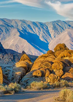
This eastern side of California is where the Great Basin Desert begins, and Lone Pine is a small town in some very big country. With a population of barely 2,000 residents, Lone Pine stretches along U.S. Highway 395 at the heart of the vast Owens Valley. To the east, the Inyo Mountains tower over the valley floor, while the Sierra Nevada rises in the west behind the jumbled boulder formations of the Alabama Hills.
As you roll into town, Highway 395 narrows, slows down, and becomes Lone Pine’s Main Street. There are Western-style buildings with awnings shading the sidewalk, while sporting goods stores, with leaping trout on their neon signs, hint at the sacred role that fishing plays in these parts. Known for its early trout season, Lone Pine is a jumping-off point for fishing both in the Owens Valley and the Eastern Sierra, including the Golden Trout Wilderness.
The easiest access to the Sierra from Lone Pine is at the 8,374-foot Whitney Portal, about 13 miles west of town. Before heading into the high country, stop in for breakfast at the Alabama Hills Café & Bakery on W. Post St., a down-home local spot that serves up a variety of filling grub, including biscuits-and-gravy and breakfast burritos.
The restaurant is aptly named for the nearby Alabama Hills, a surreal scatter of massive boulders and arches that has been a popular filming location since the silent movie era (classics such as Gunga Din and How the West Was Won were shot here). Download or pick up the Lone Pine Chamber of Commerce’s self-guided tour brochure, then take a detour from Whitney Portal Road along Movie Road. (For more about Lone Pine’s moviemaking tradition, be sure to visit The Museum of Western Film History in town.)
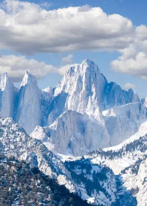
The road climbs nearly 5,000 feet from Lone Pine as it zigzags its way up the face of the Eastern Sierra before reaching Whitney Portal, the gateway for hikers bound for the summit of 14,505-foot Mount Whitney, the highest point in the contiguous United States. Outfitters like SWS Mountain Guides, Sierra Mountain Center, Southern Yosemite Mountain Guides, and many others can help safely guide you to the top on an organized trip.
Even if you’re not planning to summit Whitney, you can hike stretches of the Whitney Portal National Recreation Trail through a wooded canyon along Lone Pine Creek. Before returning to town, grab lunch or breakfast at the Whitney Portal Store and catch a glimpse of Lone Pine Creek Falls.
Featured Lone Pine
- Classic Films of Lone Pine

- Mount Whitney

Mount Whitney
- Inyo County
Inyo County
Where desert and mountains meet, Inyo County beckons outdoor explorers, history buffs, and fans of topographical extremes
- 15 Awesome June Events in California
15 Awesome June Events in California
Greet your summer with a party for the solstice, pride parades, and a huge beer festival
- Desert Road Trip Highlights With Be My Travel Muse
Desert Road Trip Highlights With Be My Travel Muse
Native Southern Californian Kristin Addis shares the best of her trip to California's remote deserts
- Follow Photographer Tiffany Nguyen’s Beach and Mountain Getaway
Follow Photographer Tiffany Nguyen’s Beach and Mountain Getaway
Track the adventure photographer as she documents the Instagram-worthy moments from around the Golden State
- Where to Travel in California Based on Your Zodiac Sign
Where to Travel in California Based on Your Zodiac Sign
Can’t decide where to go in the Golden State? Let the stars guide you…
- An Insider’s Guide to California Culinary Hotspots and Foraging Delights
An Insider’s Guide to California Culinary Hotspots and Foraging Delights
Chef Kevin O’Connor shares his favourite spots for foraging and eating across the Golden State
- Highway 395 Road Trip
Highway 395 Road Trip
Cruise through mind-boggling beauty on this desert-and-mountain drive
Videos
Podcasts
Subscribe to our Newsletter
Get weekly travel inspiration, sent directly to your inbox!
Interested in upcoming events? Looking for hidden gems?
Or tips on planning the ultimate family getaway? We've got that covered, and more.